Project title: Knowledge integration and Management Strategy Evaluation modelling
Program: Kimberley Marine Research Program
Modelling the future of the Kimberley region
| Home |
| 1 - Why Computer Models |
| 2 - What do we mean by Futures and what can be said about it? |
| 3 - The Management Strategy Evaluation |
| 4 - The models |
| 5 - Ecopath with Ecosim |
| 6 - Alces |
| Contacts |
The ALCES Simulators
The ALCES component of the project functions to model terrestrial landuse and landscape dynamics and interface with the marine ecosystem dynamics (EwE) to generate output on how these ecosystems interact and change over time. The ALCES model structure has been customized to the Kimberly study region and to enable interaction with the marine components of the project. Current GIS data is being sourced and inputted. The next phase is to develop defensible coefficients and response curves relating to landscapes, land uses, and natural disturbance regimes for the Kimberley version of the model. An online, user friendly, interactive mapping tool (ALCES Online) is being developed to facilitate stakeholder involvement through live visualization of potential scenarios in the Kimberley. The project aims to provide capacity for modeling key scenarios regarding the marine and terrestrial interface, based on rigorous scientific methods, and the ability to make this accessible to decision makers and other key stakeholders. . Additional information about the ALCES tools can be found at www.alces.ca and those wanting to learn more about ALCES Online Simulator are directed to: http://www.online.alces.ca/guide/
ALCES main purpose
The primary purpose of the ALCES model is to track the key 1st-order dynamics of terrestrial land uses and landscapes, and to generate output that is relevant to the interface between terrestrial and marine ecosystems in the Kimberley Region. Put simply, how might historical changes, and proposed future trajectories, in human populations, settlements, mining, energy, croplands, livestock, tourism, and transportation, affect (directly, indirectly) key performance indicators being assessed in both the terrestrial and marine components. Using the EwE modeling platform, detailed marine dynamics are being addressed by CSIRO team members. It is the responsibility of ALCES to generate and provide spatial and temporal information on land use and natural disturbance regimes that can be incorporated into the marine dynamics explored within EwE. A simplified IHD (impact hypothesis diagram) describes the key modules within the ALCES model intended to capture the key dynamics of the Kimberley system (Figure 1).
A key contribution of ALCES to the WAMSI project is its ability to look both back and forward in time. Based on user-defined future trajectories for each land use in the Kimberley (mining, energy, aquaculture, commercial fishing, crops, livestock, settlements, tourism, transportation). ALCES simulates the growth (and reclamation where appropriate) of all relevant footprints for each land use trajectory. Since not all stakeholders will share similar beliefs in the pace and distribution of future land use growth, it is important for the simulator to be able to adjust quickly in response to different what-if scenarios.
The general steps of attributing the ALCES Landscape and Land Use toolkit are illustrated in Figure 2. It is not sufficient for models such as EwE and ALCES to just get the science right. Ultimately, the gauge of success is the ability of the scientific community to convey the findings to a diverse stakeholder community (Figure 3) in a clear and relevant manner.
ALCES progress to date
During the past 18 months, the ALCES toolkit (ALCES Integrator, ALCES Mapper, and ALCES Online) have been structurally customized to facilitate its involvement in the MSE component of the WAMSI Kimberley project. While the structural components of the model are largely completed, there remains work in attributing the Kimberley model with defensible coefficients and response curves relating to landscapes, land uses, and natural disturbance regimes. This next step will be the focus of the ALCES Group over the next 3 months. Brad Stelfox will be in Perth during November 2014 with the intent of meeting with the WAMSI EwE/ALCES team and locating key missing data attributes.
The CSIRO/ALCES modeling team has also agreed that the ALCES Online (AO) application will be used, in conjunction with other tools, to “visualize” output from the Kimberley EwE model during stakeholder meetings. Changes to the AO interface and structure have been completed to allow this component to proceed in a reasonable timeframe.
The key to this project is the assembly of relevant GIS landscape and landuse data. To this end, the ALCES Group has been working directly with LandGate personnel to acquire the most recent data relating to landscape and landuse themes. This effort has allowed the ALCES team to acquire several geophysical and land use themes we did not possess before. The combined GIS data have allowed the ALCES Group to build a unique composite of the Kimberley region at a 2.5 x 2.5 km grid scale, comprised of 20 landscape types and 15 land use footprints. The Kimberley landscape and landuse classification is shown below in both ALCES Integrator (Figure 4) and ALCES Online (Figure 5). A composite Kimberley Region map that combines all landscape and land use footprint types is shown in Figure 6.
Once the GIS data is entered into the ALCES simulator, the model will be informed about historical trajectories that describe the temporal pattern over the past 150 years during which various land use footprints have emerged in the Kimberley region and the pattern by which landscape types were reduced in area by the growth of these landuse footprints. A first approximation of historical land use trajectories for the study area is shown below (Figure 7).
The Kimberley Region is large in area and it is important that the analysts, planners, and stakeholders have the ability to stratify the region into sub-units that are meaningful from a scientific, social, or administrative perspective. To this end, a series of GIS themes have been assembled and are being incorporated directly into the model. A list of themes assembled, or being sought, is shown below in Figure 11. An example of stratification of the Kimberley is shown for watersheds (Figure 11).
Key considerations
The central focus of the WAMSI Project is the marine domain, whose dynamics are being assessed by the EwE modeling platform. The primary role of the ALCES Kimberley model is to inform EwE about key anthropogenic changes and the role of land processes in factors that may influence marine dynamics.
The ALCES modeling platform has a foundational underpinning that all land uses create benefits, liabilities and challenges. For example, increasing the area of irrigated cropland will increase crop-related production, GDP, and employment, but is also likely to decrease wildlife habitat, increase water demand, and contribute to increased runoff of nutrients that eutrophy surface water. To create a balanced and meaningful dialogue among stakeholders about the benefit/liability interface of all land use trajectories, it is important to generate a broad suite of indicators that relate to social, economic, and environmental domains. The list of indicators being prepared in the Kimberley ALCES model (Figure 10) will certainly evolve as the model learns through its interactions with EwE, and the modeling team receives input and direction from stakeholders and program managers.
During the past few months, the release of several planning documents by the Kimberley Development Commission have emphasized a central objective of catalyzing key government and industrial policies that would enable the region to experience significant growth in infrastructure, risk capital, commodity production, and human population. All of these trajectories would create significant benefits to economic and social indicators in the region, but would also create important challenges to performance of marine indicators.
The general systems model for the Kimberley Region (Figure 1) emphasizes the importance of risk capital to commodity production, the size of the human population, and the magnitude of effects on environmental indicators in the Kimberley. In turn, the Kimberley Development Commission (http://kdc.wa.gov.au/) has emphasized the importance of social integrity of aboriginal people (health, education) in determining the amount of risk capital that will be invested in the Kimberley region. The general concept is that health and education of Aboriginal peoples will play a significant role in availability of the workforce in the Kimberley and the ability of industrial projects to build and maintain public license to functionally operate in the Region. To assist with simulating the dynamics of Aboriginal community integrity, an IHD (impact hypothesis diagram) has been developed for the Kimberley ALCES model (Figure 8) based on guidance from planning documents of the Kimberley Development Commission.
The Kimberley is an iconic tourism destination where tourism contributes significantly to the regional economy. Numerous tourism activities that are common to the Kimberley (Figure 9) are based on the expectation that the region maintains a high level of environmental and aesthetic integrity. An important element of this project, led by Dr. Michael Hughes, is to explore the dynamics between industrial landuses in the Kimberley, landscape and environmental integrity, and the dynamic viability of the tourism economy.
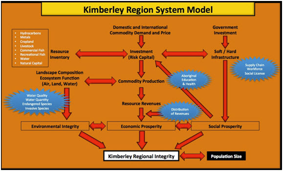 |
Figure 1. Simplified impact hypothesis diagram (IHD) describing the key components of the Kimberley Region system. |
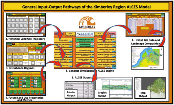 |
Figure 2. Generalized steps for attributing the Kimberley Region ALCES simulator toolkit. |
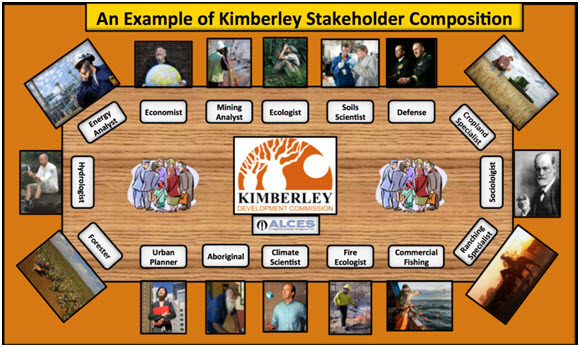 |
Figure 3. Examples of possible stakeholders for the Kimberley Region. |
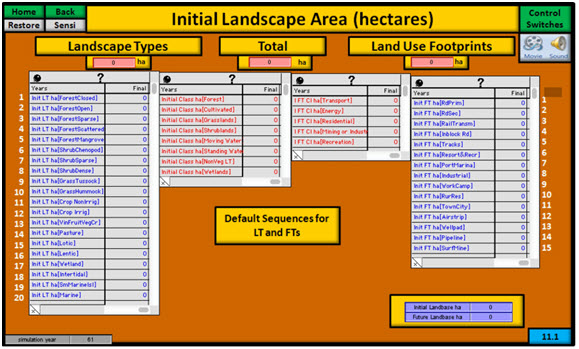 |
Figure 4. Stratification of Kimberley Region into landscape types and land use footprint types. |
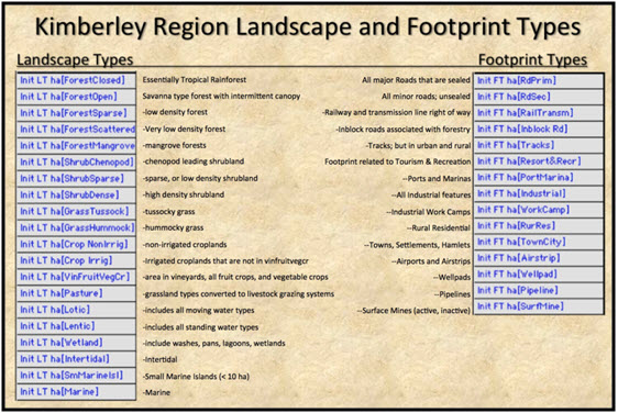 |
Figure 5. Stratification Scheme for the Kimberley Region. |
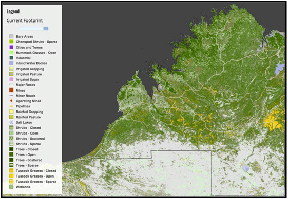 |
Figure 6. Generalized image of the Kimberley Region, illustrating the landscape types and some of the current anthropogenic footprint relating to transportation, mining, and settlements. |
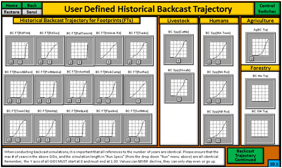 |
Figure 7. Example of historical backcast curves for the footprints of the Kimberley Region. |
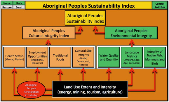 |
Figure 8. Impact hypothesis diagram for Aboriginal Peoples Sustainability Index. |
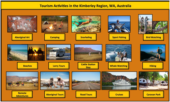 |
Figure 9. Examples of tourism activities in the Kimberley that are based on high levels of environmental and aesthetic integrity. |
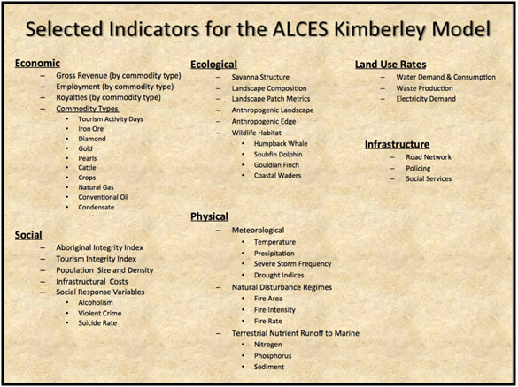 |
Figure 10. Current list of key indicators for the Kimberley Region. |
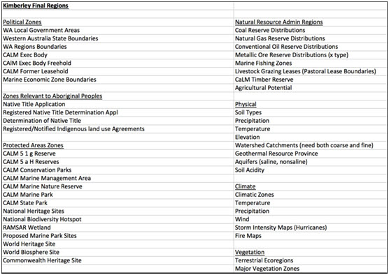 |
Figure 11. GIS region themes for the Kimberley project. |
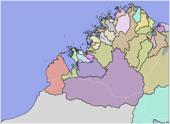 |
Figure 12. Watershed basin classification as an example of a stratification region in Kimberley Region. |